Showing posts with label SLS. Show all posts

Monday, November 10, 2025

ACP Tourist Personality Type

Awesome creation by Wenxin using Authoring CoPilot (ACP) in SLS.

🎮 Building Your Own “Choose-Your-Own-Adventure” or Personality Quiz… in Under 5 Minutes!

She used ACP to turn her idea into a working HTML5interactivee based on a tourist personality quiz based on the “Venturer” and “Dependable” traveller types. 

This is what she did:

1️⃣ Used ChatGPT to generate quiz questions based on the personality traits. 

2️⃣ Got it to create an auto-scoring system so the quiz could sort students into different profiles. 

3️⃣ Asked it to produce a single-file HTML5 interactive prompt, complete with scoring logic, navigation, and result screens. 

4️⃣ Dropped the prompt directly into ACP.

This HTML5 interactive generation feature will go live on SLS on 4 December evening after the R3 release.


Many thanks to Wenxin for sharing this!

https://www.facebook.com/share/p/17y3WjX2Qj/ 

How HTML5 interactives align with KAT by Matthew.

https://www.facebook.com/share/v/1CLNHRpQi5/


You can read more about AI in SLS here:

https://www.learning.moe.edu.sg/teachers/teaching-and-learning-on-sls/aied-features/

Tuesday, November 4, 2025

Refreshed Upper Sec IDT for 2026

The Upper Sec IDTs have been refreshed. The list of IDTs is available here. 
https://docs.google.com/spreadsheets/d/1T3vDNVju0uqHEvykw38ksvQqozqxbO9GSL9U4NcX5mU/edit?gid=1934267397#gid=1934267397

If you would like to make a copy, do remember to rename it according to the unit e.g. replace [IDT] with 1.1.1.1 so that it will be in sequence when you make a copy in my folder. Create a new folder 2026 Upper Sec


The New IDTs incorporated the use of AI - SALIS to create immediate feedback to student's responses. 


Wednesday, January 15, 2025

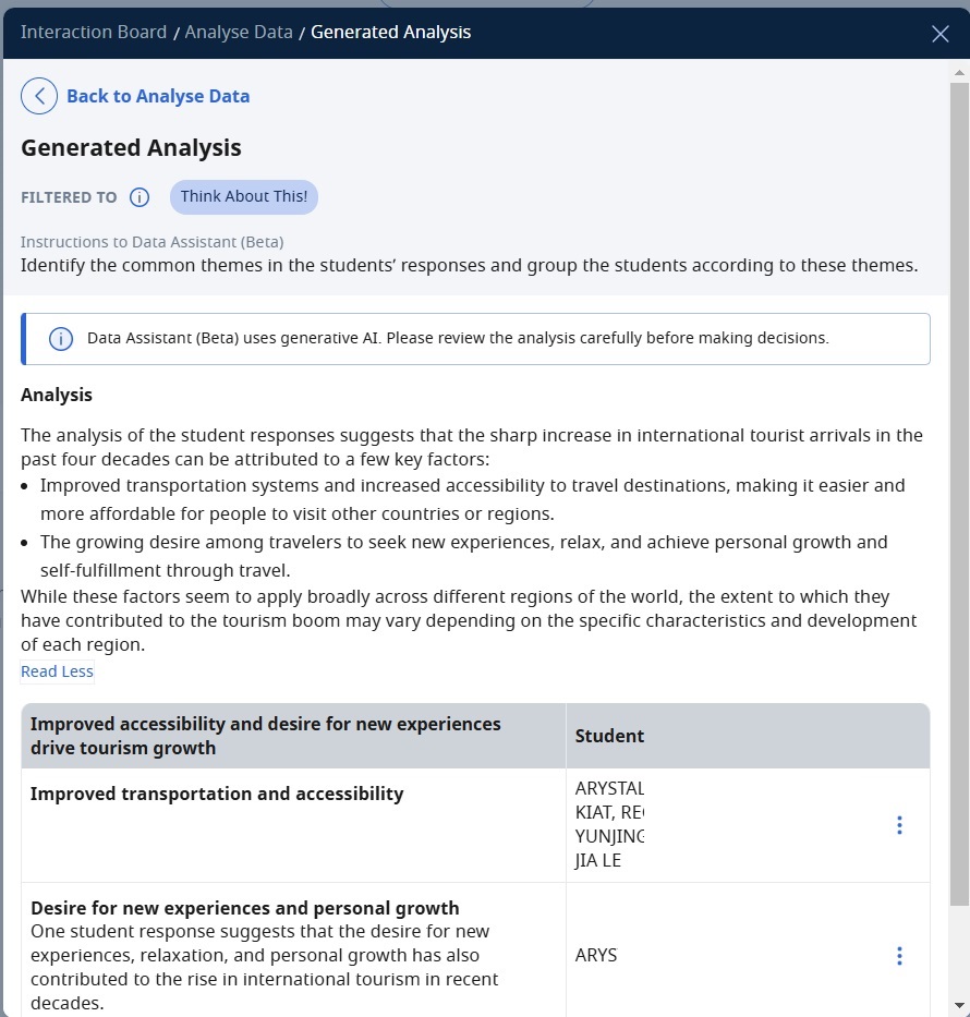
AI integrated ITT in SLS

The AI analysis in ITT function is already integrated. Simple to use to filter the responses. AI will generate the analyse but the downside is it cannot be saved so I had to screenshot.

 It is simple to use - just click on the icon which I circled here. Then type in what you want AI to filter and analyse. 


Friday, November 13, 2020

New GI Stages & SLS activities

There are 5 Stages in the new syllabus for Geographical Investigation with the newly introduced stage of suggesting improvements and taking actions. I also like it that the activities for the Sec 1 is now in the form of SLS lessons. There are a total 29 SLS lessons for the Sec 1 new syllabus based on diagnostic, knowledge acquisition, geography in practice, self-check and skills practice. A separate 5 SLS lessons have been designed for the Sec 1 GI on Water (Kallang river and Jurong Lake) as well as GI on Tropical Rainforest..


The list of SLS lessons for the new syllabus is available here: go.gov.sg/lsg001

I would propose creating a folder 2021 Sec 1 in My Drive and after you made a copy, save it in the folder. I would also suggest replacing copy of with a number (two digits e.g.01) so that the lessons are in sequence.


I have modified the one on Water GI to that on Lorong Halus Wetland beside the Serangoon River & Reservoir. I will be sharing the one I have modified. 

Please do refer to this shared excel on the SLS lessons related to Geography:


I would really like to encourage all to join in SGLDC!
I find the above features very useful. You can also read some of my posts on SLS:


Thursday, August 22, 2019

Open classroom on using SLS to teach geographical concepts

Greendale Secondary School open classroom on the topic deforestation. An opportunity for us to see how the teacher uses SLS to blend in assessment for learning and geographical concepts in the teaching of the topic on "impacts of deforestation". Tapping on the embedding function and the use of simple analytics from students' responses, the lesson showcases the use of updated features such as the thinking routine in SLS.

We were given a chance to view a blended lesson 1 of 2 lessons in the sub topic of impacts of deforestation with a class of 40 Sec 1 students.    

The teacher made use of the SLS platform to support the inquiry based learning.  The teacher led the class in looking at the geographical issue with a poll in SLS on what the students think is the most significant impact of deforestation. He proceeded to task each pair to look into an assigned impact with a variety of geographical resources in the form of text extracts, diagrams and videos embedded in SLS i.e. E1 pair to look at impact on biodiversity, E2 pair to look at impact on water catchment and E3 on enhanced greenhouse impact. The students recorded what they had learned from the resources on the impact assigned to them in the SLS thinking routine. The teacher quickly bookmarked a few responses and highlighted some concepts which the students had shown to be lacking in their understanding from the thinking routine responses. e.g. the teachers clarified what is surface run-off and how it can contribute to river flooding. He also made a point to highlight the inter-connectivity of the various impacts. 

Then the students proceed to change their partners at their table to share with the other students on why the impact is more significant than the other (expert group strategy). The lesson ended with a revisit to the question on what they now think is the most significant impact of deforestation and the students responded individually on SLS thinking routine.

The design map of the lesson shared:


Before we proceeded to the classroom to observe the students for the lesson, we were reminded that we would be taking turn to be at the tables to make the observation of students' responses. (20 seated at the tables with the students and 20 seated at the back to observe and then swopped).

We were given the following recording sheets to record our observations:


The sharing ended with a discussion on the planning and enactment considerations in the conduct of the lesson. What we observed in the lesson which thinking was made visible and how students collaborated to make sense of the geographical concepts as well as how formative assessment was weaved into the lessons.


 Our takeaway:


Thoughts on the lesson shared with us-

1. Be willing to give up some control - a true student-centered lesson needs to be led by student actions.

2. Using SLS means students can access learning materials in their own time, at their own pace - they are not limited by their prior knowledge or access to information.

3. Have high(er) expectations of students - they will usually surprise you with what they are capable of.

4. Consider the highest value use of classroom time (e.g. discussion, sense-making) & do that.

5. An SLS lesson can be covered over several F2F sessions - you can release segments over.

6. The definition of what a lesson is can extend beyond classroom time (e.g. pre, post lesson learning) - we may want to explore how we think about lessons and reframe our definition of what constitutes a lesson.

7. The 4 Vs of data - value, volume, velocity, veracity - make managing student inputs increasingly challenging. We will need to evolve new strategies for managing them.

8. One strategy to manage the increased volume & velocity of data might be to consider peer/self-assessment strategies, both online (e.g. have students comment on each others' responses) & F2F (e.g. getting students to clarify with each other).

9. We should use SLS to make our teaching better, not only easier - it should make low-value activities easier (e.g. searching for resources, collating student inputs, distributing feedback) & free time up for us to do more high-value activities (e.g. designing learning experiences, exploring different ways to reach out to different students, crafting feedback). 

10. The learning artefacts (e.g. student responses) of one lesson can be used as teaching materials in subsequent lessons.


SLS is an enabler for better teaching & learning:

1. Rich repository of quality, curriculum aligned resources

2. Promoting visible interaction (student-content, student-student, student-teacher) for learning

3. Opportunity to change the way we deliver learning experiences (e.g. more inquiry, authentic conversations)

You can refer to some of my posts on the use of SLS @

http://ezitnew.blogspot.com/search/label/SLS?m=1

Saturday, May 18, 2019

Compass direction and Compass bearing simulation using Geogebra

Awesome sharing by Wei Sern from SGLDC on creating interactive exercises in Geogebra. This is useful especially when embedding html code is available end of June in SLS. You can also use the code to embed on Google sites and Blog (like the one below)

Reading compass bearing created by Wei Sern:

https://ggbm.at/hydx8tm2


1. Check the box next to "Use Protractor" so that the protractor will appear.
2. Read the question on where to measure the bearing from.
3. Select "Move compass to A or B" as shown in question.  E.g. point B
4. Drag the protractor and rotate it so that O points to the north. (If the angle is more than 180° then rotate the protractor with 0 starting from South and the read the angle. Add 180°to the reading.)
5. Drag the pin head so that the line intercept with the point it is measuring to e.g.point A
6. Read the angle from the protractor and enter the number into the keypad with the degree symbol.
7. Click on "Enter Check".


If you want to get the code to embed, you need to download the GGB file  (e.g from https://ggbm.at/hydx8tm2)and then upload as your activity in your GeoGebra account. Then in your GeoGebra account you can follow the following steps to get the code to embed in you blog or site:

I have commented earlier how I missed the earlier ETD game of using interactive game to learn compass bearing. Learned from him that compass bearing is also learned in O level E Maths and that he could create the simulation in geogabra.  Students kinestatically learn how angle bearings of one location from another is referenced. It allows the sttudents to move a virtual compass and then input the value of the angle.

The original exercise had some drawbacks when used on a mobile phone, hence he had improved on it by including a virtual customized keyboard which allows the activity to be run on phone browser with better graphics control and interface.

He also mentioned that the protractor tool can be made into a template file and inserted into any existing good quality Geogebra geometry activity resource without too much effort! It can be downloaded from
 https://www.geogebra.org/m/t6v92Gdz#material/tedq8qnf 

Can you move the animal to the correction direction?


https://iwant2study.org/lookangejss/math/ejss_model_Eight_point_compass3/Eight_point_compass3_Simulation.xhtml

Saturday, April 27, 2019

Interactive media for map reading on SLS

So happy to find that interactive media from ETD is now included in SLS. Would really hope that the older interactive e.g. grid reference - fun with building and grid bearing - flying a plane are also included! The only draw back with the existing one is the absence of 4-figure and 6-figure grid reference. However still love the games Sailing with bearing and Quest of Arudra Island.


Added the interactive media on lesson review - "How to read a map (part 2) features of a map."


Added the interactive media on the game  "Quest on Arudra Island"


Added the interactive media on the game  "Sailing with Bearing"

To overcome the issue of the lesson review not showing the 4-figure and 6-figure grid reference, thinking of using the thinking routine to get the students to draw it out.