Myself and Arman shared on Harnessing Technology for GI for the 2021 Geography symposium.
Harnessing Technology for GI


Please see the padlet for the link to the resources shared:
Myself and Arman shared on Harnessing Technology for GI for the 2021 Geography symposium.
Please see the padlet for the link to the resources shared:
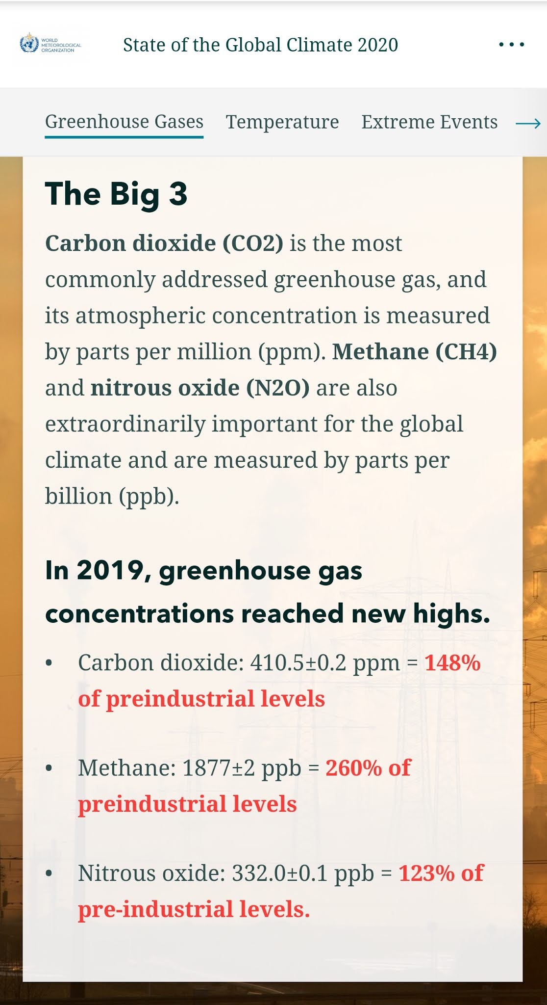
Interesting interactive from ST on reducing CO2 https://www.straitstimes.com/multimedia/graphics/2021/10/singapore-carbon-emissions-climate-change/index.html?shell


Really grateful to Google Earth and Google Suite for enabling the students to continue in their Geographical Investigation despite the pandemic.
Would really love to share with the other Geography teachers how we carried it out and how they can adapt it for their school!

Do join in the Geog symposium as I will be sharing with my colleague in one of the concurrent session.
https://sites.google.com/view/gysympo2021/home?authuser=0


List of merged tag you can use with the custom cert

Remember to publish the Google slide template to the web (you can select this from the drop down under File menu)
The following are the Google forms I created which I added certify'em. I gave the students as a form of checklist after I have covered every topic and they enjoyed receiving the certificate.
I was pleasantly surprised when a boy came up to me and ask me for the next one and I had to tell him we still have one more part to finish up the chapter. It's always a joy to see the students excited about learning. I have also learned from the feedback the areas which the students are not so confident in as well as getting feedback from them how and what they would like to learn more.
Feedback for the various topics:
PG Weather and Climate https://docs.google.com/forms/d/1fMmZSsBuMVIdsimz7oCki2KDbQnwIJ2jq4ACmsB_VBs/copy
Elective Weather and climate https://docs.google.com/forms/d/1lVDxRbH9iHSUgKO2bDBeZOZvJL_xqyxF944BwhQ06xM/copy
Food resources
https://docs.google.com/forms/d/1dy3yI1xoAwgqQopR-CTbRdZ7OHUY2vIZOSmm_MEIzZs/copy
Elective Food resources
https://docs.google.com/forms/d/1zyJE6lSZs_GT-8I3kLp8FfxFafl1q_Ug1BZzZrZwgKE/copy
Tourism https://docs.google.com/forms/d/18vmnpi-pahbu7BWjXK_OItq62s9PFyPAIVP05bIl1u8/copy
Tectonic Hazards https://docs.google.com/forms/d/1RYAc4kwk88tT9c7GKOo61am_A457kMhNv1EN6-8s6wY/copy
PG Coasts https://docs.google.com/forms/d/1Ayur7IuwVsnEZyD2tDBKGZjdT4uYShV7CoKirRzdQ0o/copy
PG Health and Diseases https://docs.google.com/forms/d/1QACRMAKPWWt5Dv0lyy9OLFyBHZ9m3Dyd8xU8qgca50k/copy
The design of the lesson with the active learning process and key application of technology in mind.
Due to the pandemic, we were unable to conduct the actual fieldwork so I have used Google Earth and Google suite to conduct a simulated GI.

My colleague, Arman, coordinated the Weather GI. With the use of technology, we were able to continue the GI into the HBL period.
Students formulated their hypotheses in Google classroom and I went through with class the hypotheses they have formulated. Three were chosen and the students collected the data using a weather tracker in school. The students then record in the Google form and the data is collated on a spreadsheet. Using the data, comparative graphs and scatter graphs are generated for the data representation.
The groups collaborated in presenting their analysis and conclusion using Google slides. Images from a group's presentation is shown below.
The use of the Google suite and Google Classroom has helped to create a more engaged blended learning experience for the students using technology.
https://sites.google.com/a/moe.edu.sg/sec3geog/geographical-investigation/20-weather-gi?authuser=0


Interesting historical maps to see the development of Singapore.
I like that you can allow for swipe of two maps as shown below:

We opened our classroom for teachers from another school to show how our students used their personal learning devices in class.
We had started on 𝟭:𝟭 𝗣𝗲𝗿𝘀𝗼𝗻𝗮𝗹 𝗟𝗲𝗮𝗿𝗻𝗶𝗻𝗴 𝗗𝗲𝘃𝗶𝗰𝗲 using iPad in 2019 and it was a real blessing for 2010. I must thank our HOD ICT in rolling out the 1:1 PLD program and also ensuring the infrastructure support such as 𝗔𝗽𝗽𝗹𝗲 𝗧𝗩 so that we can mirror our iPad screen to the projector screen easily.
Of course I am also thankful that we are already on the 𝗚𝗼𝗼𝗴𝗹𝗲 𝗦𝘂𝗶𝘁𝗲.The ease of organising the lessons via the 𝗚𝗼𝗼𝗴𝗹𝗲 𝗖𝗹𝗮𝘀𝘀𝗿𝗼𝗼𝗺 and the ability for the students to use technology in their learning. The Sec 3 had fun on an overseas virtual fieldwork in UK and made interesting findings on 𝗚𝗼𝗼𝗴𝗹𝗲 𝗘𝗮𝗿𝘁𝗵. The Sec 1 love that they can explore the field sites along the Punggol waterway from their seats using 𝗚𝗼𝗼𝗴𝗹𝗲 𝗘𝗮𝗿𝘁𝗵. They would have gotten all wet if they had gone there for their GI as it started raining so heavily.
Sec 1
We completed stage 4 of our Water GI using 𝗚𝗼𝗼𝗴𝗹𝗲 𝗖𝗹𝗮𝘀𝘀𝗿𝗼𝗼𝗺, 𝗚𝗼𝗼𝗴𝗹𝗲 𝗘𝗮𝗿𝘁𝗵 as well as 𝗚𝗼𝗼𝗴𝗹𝗲 𝗦𝗹𝗶𝗱𝗲𝘀 for collaboration. I have placemarked the field sites and embedded the data they had collected from their water test.


The groups entered the data into 𝗚𝗼𝗼𝗴𝗹𝗲 𝗙𝗼𝗿𝗺 and the teachers were able to help the classes collate their data for the to analyse on the 𝗚𝗼𝗼𝗴𝗹𝗲 𝗦𝗽𝗿𝗲𝗮𝗱𝘀𝗵𝗲𝗲𝘁. They were able to make observations of the field sites using the street view and explained how the features they have observed on 𝗚𝗼𝗼𝗴𝗹𝗲 𝗘𝗮𝗿𝘁𝗵 showed human activities and the impacts on the waterway. They are able to collaborate with their members to present the conclusion on their GI using 𝗚𝗼𝗼𝗴𝗹𝗲 𝗦𝗹𝗶𝗱𝗲𝘀. https://sites.google.com/a/moe.edu.sg/sec-1-geog-2021/2021-water-gi

To show the changes overtime I have also used Juxtapose JS to create a time slider using 𝗚𝗼𝗼𝗴𝗹𝗲 𝗘𝗮𝗿𝘁𝗵 images from 2010 and 2020.
We used Google Earth to understand coastal studies for map reading. I have integrated a topographical map into the 𝗚𝗼𝗼𝗴𝗹𝗲 𝗘𝗮𝗿𝘁𝗵 file. The students visited the south of UK (Seaton) and learn how the map representation came alive with 𝗚𝗼𝗼𝗴𝗹𝗲 𝗘𝗮𝗿𝘁𝗵 showing them the actual site of coastal landforms they have studied. They also better understand the concept of space, scale and place as they made measurements of the spit and made observations of how the spit has affected human activities in the area. https://sites.google.com/a/moe.edu.sg/sec3geog/google-earth
This was continued from the Coastal GI using 𝗚𝗼𝗼𝗴𝗹𝗲 𝗘𝗮𝗿𝘁𝗵, 𝗚𝗼𝗼𝗴𝗹𝗲 𝗦𝗽𝗿𝗲𝗮𝗱𝘀𝗵𝗲𝗲𝘁 and 𝗚𝗼𝗼𝗴𝗹𝗲 𝗦𝗹𝗶𝗱𝗲𝘀 on 15 Mar. With Google Earth, the students visited the place marked field sites and made observations of the environment. They annotated a field sketch to explain the coastal processes which could have affected their investigation. It is blended learning as I also included the fieldwork simulation of measuring the sediments I had collected. They did the wave frequency via a pre-recorded video. They also measured the gradients on the models I have created. https://sites.google.com/a/moe.edu.sg/sec3geog/geographical-investigation/gi---coast/2021-coastal-gi-fieldwork-simulation
Useful interactive on climate change shared by my colleague.
https://storymaps.arcgis.com/stories/6942683c7ed54e51b433bbc0c50fbdea


Great e-resources from Conservation International Asia Pacific with videos, worksheets and quizzes!
https://www.conservation.org/singapore/virtual-learning
The 5 episodes at a glance:
EPISODE 1: WHAT IS CLIMATE CHANGE?


Changi beach is a popular place for beach and water activities for many. However, the waves are strong and coastal erosion has taken place.


