Showing posts with label Google Earth. Show all posts

Wednesday, November 9, 2022

Voyager in Google Earth App

I have been using Google Earth and have written on the use of it earlier. Here I would like to expand more on the use of Voyager in the Google Earth App as many students are using the Google Earth app in their mobile devices such as iPad.

The use of Google Earth has been great to understand the concepts of Space, Scale, Place and Environment in Geography

Games in Voyager

You can click on the wheel like icon to access Voyager. One of the category in Voyager is GAMES. I have recently gotten the students to play the game Where is Carmen Sandiego. 

When students click on an interviewee in the game, they will automatically zoom-in on the location of the interview. Just like in any other use of Google Earth, the students can zoom and pan around the area of detail.
Great for learning about places around the world! After talking to the witnesses, the students have to use the information to make their best guess as to where they should fly to next from a given list to pursue Carmen Sandiego.

A second version 
Tutankhamun’s Mask and a third version Keys to the Kremlin are also available under GAMES in Voyager. 

As the students play the game, they learn the names of the places they visit virtually. They can learn the uniqueness of the place which attract tourists and were reminded to relate it to what they have learned in the topic on tourism:
Places which attract tourists
Places of scenic beauty
Places with rich culture
Places with facilities
Places with conflicts


Another category under voyager is LAYERS. I love the one on Current Hurricanes & Tropical Storms which show the path of recent hurricanes and tropical storms. Tsunamis in History help students to see how large volcanic eruptions and underwater earthquakes can result in Tsunamis which impact on many regions. The students would acquire a greater sense of the scale of impact from the phenomena. 


Especially useful will the Timelapse under Layers. The students can explore the unique Earth's ecosystem which is covered in the new upper sec syllabus. Exploring the function, impacts and restoration of Earth's ecosystems under EDUCATION in Voyager. 

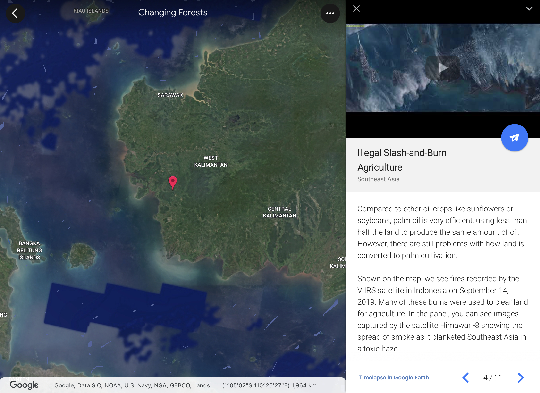
Love the one on Changing Forests under Timelapse in Google Earth. One can observe the changes over time on the changing landuse and how it impact on the forest in different parts of our Earth. The students will be able to investigate and respond to the geographical issue of deforestation in different parts of the world with a better understanding of Place, Space, Scale and Environment. 


The students can explore the unique Earth's ecosystem which is covered in the new upper sec syllabus. Exploring the function, impacts and restoration of Earth's ecosystems under EDUCATION in Voyager. 


Students can continue to explore the culture category in topics such as Orang Asal Indigenous Lands of Malaysia.


Voyager in Google Earth will allow the students to explore the world and have a better understanding of Place, Space, Scale and Environment. 


Wednesday, June 1, 2022

Using Google Earth and image slider

 Using Google Earth, you can easily access the satellite image of the area in the past. Just click on the year which appears on the left bottom corner and it will bring up a time slider in the top left. Select the time period you want and screenshot the image. Examples are screenshot for ECP.


ECP 2010

ECP 2021

Using https://juxtapose.knightlab.com/ you can generate the image slider for easy comparison of the 2 images. You can embed it with the html code generated like below. Or just copy the link and give to the students

https://cdn.knightlab.com/libs/juxtapose/latest/embed/index.html?uid=0a47ee14-e230-11ec-b5bb-6595d9b17862

Students can easily compare the 2 images. How effective is the breakwaters in protecting the East Coast? You can see that there the beach has grown bigger, probably due to the greater amount of beach deposit.

A great way to compare the images in terms of spatial and temporal scales.


Sunday, March 27, 2022

Google Earth for Coastal Studies

Gotten the students to explore the South coast of England (Seaton ) using Google Earth. I have place marked 7 sites for them to study the coastal features and processes. 

You can access the Google Earth file here - https://tinyurl.com/GEcoastmap  


Using the ruler function, they could measure the length and width of the spit. They could also infer the direction of the longshore drift using the north arrow and observing how the spit has extended from the land towards the sea across the river mouth. 

The ability to conduct virtual fieldwork without being there physically. 


Google Earth also allowed authentic learning as they make comparison of the scale in the real world and make observations using virtual reality. 

Pleasantly surprised this time round to see two students screenshot and annotate on them what I highlighted on the coastal features using Google Earth. Students are motivated to apply their learning and make observations from the Google Earth real life images. 


Google Earth instruction for coast - https://drive.google.com/file/d/173446JmZcbQ4imuqqOCwCEmlachN5psW/view?usp=sharing

Google Earth worksheet for coast - https://drive.google.com/file/d/13JXLDUftvZjvW-LobXc7mkLH7gkVh-Tx/view?usp=sharing


Wednesday, June 30, 2021

E-Pedagogy in Coastal GI

 
Technology should enhance learning and help the students achieve the learning objectives.

The design of the lesson with the active learning process and key application of technology in mind.

Due to the pandemic, we were unable to conduct the actual fieldwork so I have used Google Earth and Google suite to conduct a simulated GI.


Coastal GI using Technology 


Tuesday, March 30, 2021

Google Earth for Water and Coastal GI

We opened our classroom for teachers from another school to show how our students used their personal learning devices in class. 

We had started on 𝟭:𝟭 𝗣𝗲𝗿𝘀𝗼𝗻𝗮𝗹 𝗟𝗲𝗮𝗿𝗻𝗶𝗻𝗴 𝗗𝗲𝘃𝗶𝗰𝗲 using iPad in 2019 and it was a real blessing for 2010. I must thank our HOD ICT in rolling out the 1:1 PLD program and also ensuring the infrastructure support such as 𝗔𝗽𝗽𝗹𝗲 𝗧𝗩 so that we can mirror our iPad screen to the projector screen easily. 

Of course I am also thankful that we are already on the 𝗚𝗼𝗼𝗴𝗹𝗲 𝗦𝘂𝗶𝘁𝗲.The ease of organising the lessons via the 𝗚𝗼𝗼𝗴𝗹𝗲 𝗖𝗹𝗮𝘀𝘀𝗿𝗼𝗼𝗺 and the ability for the students to use technology in their learning. The Sec 3 had fun on an overseas virtual fieldwork in UK and made interesting findings on 𝗚𝗼𝗼𝗴𝗹𝗲 𝗘𝗮𝗿𝘁𝗵. The Sec 1 love that they can explore the field sites along the Punggol waterway from their seats using 𝗚𝗼𝗼𝗴𝗹𝗲 𝗘𝗮𝗿𝘁𝗵. They would have gotten all wet if they had gone there for their GI as it started raining so heavily. 

Sec 1 

We completed stage 4 of our Water GI using 𝗚𝗼𝗼𝗴𝗹𝗲 𝗖𝗹𝗮𝘀𝘀𝗿𝗼𝗼𝗺, 𝗚𝗼𝗼𝗴𝗹𝗲 𝗘𝗮𝗿𝘁𝗵 as well as 𝗚𝗼𝗼𝗴𝗹𝗲 𝗦𝗹𝗶𝗱𝗲𝘀 for collaboration. I have placemarked the field sites and embedded the data they had collected from their water test. 


The groups entered the data into 𝗚𝗼𝗼𝗴𝗹𝗲 𝗙𝗼𝗿𝗺 and the teachers were able to help the classes collate their data for the to analyse on the 𝗚𝗼𝗼𝗴𝗹𝗲 𝗦𝗽𝗿𝗲𝗮𝗱𝘀𝗵𝗲𝗲𝘁. They were able to make observations of the field sites using the street view and explained how the features they have observed on 𝗚𝗼𝗼𝗴𝗹𝗲 𝗘𝗮𝗿𝘁𝗵 showed human activities and the impacts on the waterway. They are able to collaborate with their members to present the conclusion on their GI using 𝗚𝗼𝗼𝗴𝗹𝗲 𝗦𝗹𝗶𝗱𝗲𝘀. https://sites.google.com/a/moe.edu.sg/sec-1-geog-2021/2021-water-gi 

To show the changes overtime I have also used Juxtapose JS to create a time slider using 𝗚𝗼𝗼𝗴𝗹𝗲 𝗘𝗮𝗿𝘁𝗵 images from 2010 and 2020.

Sec 3 

We used Google Earth to understand coastal studies for map reading. I have integrated a topographical map into the 𝗚𝗼𝗼𝗴𝗹𝗲 𝗘𝗮𝗿𝘁𝗵 file. The students visited the south of UK (Seaton) and learn how the map representation came alive with 𝗚𝗼𝗼𝗴𝗹𝗲 𝗘𝗮𝗿𝘁𝗵 showing them the actual site of coastal landforms they have studied. They also better understand the concept of space, scale and place as they made measurements of the spit and made observations of how the spit has affected human activities in the area. https://sites.google.com/a/moe.edu.sg/sec3geog/google-earth 

 This was continued from the Coastal GI using 𝗚𝗼𝗼𝗴𝗹𝗲 𝗘𝗮𝗿𝘁𝗵, 𝗚𝗼𝗼𝗴𝗹𝗲 𝗦𝗽𝗿𝗲𝗮𝗱𝘀𝗵𝗲𝗲𝘁 and 𝗚𝗼𝗼𝗴𝗹𝗲 𝗦𝗹𝗶𝗱𝗲𝘀 on 15 Mar. With Google Earth, the students visited the place marked field sites and made observations of the environment. They annotated a field sketch to explain the coastal processes which could have affected their investigation. It is blended learning as I also included the fieldwork simulation of measuring the sediments I had collected. They did the wave frequency via a pre-recorded video. They also measured the gradients on the models I have created. https://sites.google.com/a/moe.edu.sg/sec3geog/geographical-investigation/gi---coast/2021-coastal-gi-fieldwork-simulation


Tuesday, November 24, 2020

SGLDC sharing on VR LJ and simulated fieldwork

Just some reflection on our sharing in SGLDC Virtual Meet II on 23 Nov 2020.

The SGLDC team should be sharing all the video recordings and slides of what had been shared soon. For those who have yet to join the SGLDC Facebook group (only for MOE staff) do join in and check out what the others have generously shared! 

I like that Madeline has touched on CCPD 360 resources as well as the use of Kuula in adding information to 360 images to give the students a more enriched virtual learning experience. I have shown how Google Earth can be used with other Google tools in VR simulations. Both our sharing are more teacher centric with resources the teachers can use and create for their students. Theophillia sharing is more student centric as she empowered her students to create using VR devices and the Cospaces Edu app. This enable the students to create a personalised VR learning experience and to attain the highest cognitive process on Bloom's taxonomy. 

 A screenshot of the slides I shared:


Use of Google Earth for inquiry based learning and GI
Sec 1 Google Earth
https://sites.google.com/a/moe.edu.sg/sec-1-geog-2021/google-earth

Human Geog Google Earth  https://sites.google.com/a/moe.edu.sg/sec-4-geography/google-earth

Virtual Coastal GI and simulated Fieldwork - https://tinyurl.com/coastalGIVR

And if you would like me to share the SLS lessons (5 stages) which I modified the field site to Lorong Halus for the new Sec 1 syllabus 2021 - please fill up this form via ICON email address https://tinyurl.com/lilysharesls

I will do so after I have collated the list by end of Nov 2020.
(easier to just add from the collated csv- thanks)


Wednesday, May 27, 2020

Virtual Learning Journey and simulated GI

The video below is a 360 video I took of the Chinatown LJ for Tourism GI I have conducted in 2020. You can also move horizontally through the 360 video by dragging your finger across the screen if you are using your handphone. You may also pause the video and swipe on the screen for the 360 view. Though you cannot experience the smell, the sight and sound would be an amazing VR experience. You can watch it in VR if you open up the video in Youtube. Experience the virtual reality with VR glasses. 

Virtual Tourism GI


More of 2020 tourism GI here 

Did a virtual Coastal GI in UK too using Google Earth. An overseas virtual learning journey!
Gotten the students to make observation using street view as well using the ruler in Google Earth to do measurements. I actually gotten the students to 'fly' back to Singapore to compare the size of the one we have at ECP with that in UK. Gotten them to think why are the breakwaters wider in UK.
Google Earth Kmz file and worksheet I have created can be downloaded from my Google site @

Sec 1 virtual Water GI using Google Earth. Let's fly over to Lorong Halus!
Students learn more about the history of the place.
https://sites.google.com/a/moe.edu.sg/sec-1-geog/geographical-investigation/5-lorong-halus-wetlands

They can also see how the place was in the past using the time slider with Google Earth.
https://sites.google.com/a/moe.edu.sg/sec-1-geog/google-earth

Then visit the various location via the street view on Google Earth.


An annotated sketch submitted by a Sec 1 student.

Will be customising the 2021 SLS lessons on GI to that on Lorong Halus. Will do the sharing on SGLDC on 23 Nov!

For sec 2 we actually gotten the students to annotate a picture of their neighbourhood to show why it is a unique place for them. Some were not able to be there so they made use of Google Earth and screenshot the street view/photo sphere for the 360 view. They could screenshot images of their neighbourhood and annotate them to show why it is unique to them.


Updated  5 June- Alex shared on the following 360 video of the Toa Payoh Neighbourhood.


This also reminded me of the sharing on using VR for Housing GI shared by Hua Yi sec
http://geogshare.blogspot.com/2019/11/vr-in-geography.html

Updated: use of VR in Geog and Eng by Ms Yong from Teck Whye Sec

Do also look at my earlier post on the use of MOE arcgis resources.
http://geogshare.blogspot.com/2020/03/arcgis-resources.html
 
I have always love Google Earth - My earlier posts on the use of Google Earth:
http://ezitnew.blogspot.com/search/label/Google%20Earth

The use of Google Earth definitely encourage real world exploration. It enables the students to overcome the constraints of space and time, bringing the world into the classroom. Google Earth allows students to locate and explore different parts of the world and the time slider allow one to compare the before-and-after images of an area.   This can definitely help to spark curiosity about the causes and impacts of change as what I have mentioned earlier about the Sec 1's study of Lorong Halus.  

In instances where the location of a study is difficult to reach, teachers can take students on virtual tours. Virtual tours may be in the form of the drag and drop Pegman icon on Google Street View's 3D view. The students could take a virtual trip to see why Machu Picchu in Peru attracts the tourists by moving around the ruins left by the Inca civilisation as well as experience the amazing view from the mountain top. 

Students can zoom, pan, and rotate the orientations of their screen in Google Earth to help them understand geographical space, place, and scale. As mentioned above, the students can use the search and zoom functions on Google Earth to explore Lorong Halus. The ability to observe features in Google Earth by manipulating the map scale actively and easily allows students to have a better sense of how the waterway, e.g Punggol waterway, are connected at a locale and even factors that may affect the water quality in the waterway. 

My Sec 3 students have also enjoyed measuring the breakwater in UK and compare that to the one at ECP using the ruler function in Google Earth. In doing so they could better understand the geographical concept of scale as well as making observations on the reasons for the difference in sizes.  Spatial analysis could be carried out and exploration of the real world without them actually being there with virtual field trips!

Updated 20 Oct 2020
Updated below is my Sec 3 virtual Coastal GI. Making use of Google Earth to help them see the authencity of their "fieldwork", simulated GI with measurement using samples, model, video clips etc at 7 stations in school! The students collaborated in the collection of data using Google Sheets and represent their data using Google slides.

Google Earth allowed my students to "fly over" to East Coast Park and Tanjong Rimau in Sentosa which will not be possible without the use of technology. It had definitely redefined the tasks.

 
You can make a copy of the Google sheet which the students used to record their measurements.

The 5 stations at East Coast Park, Singapore.

The 2 stations at Tanjong Rimau in Sentosa.


Explanation on the data collection methods before getting the group's to rotate on the 7 stations.


Virtual flight to ECP via Google Earth. Students took a screen shot and annotate to explain their observation on coastal process, coastal features and human intervention.

Measuring the wave frequency from recorded video taken at ECP.  Students imagine themselves to be at ECP looking at the place mark on Google Earth.


Sediment size analysis for larger sediment using a corner caliper.

Sediment size analysis for finer sediment using a weighing scale and sieves.

Measuring the slope of the beach facing the updrift and downdrift.

My HOD help me to guide the students in using the ranging poles and clinometer in measuring the beach profile.