Friday, November 15, 2019

VR Geography of Food

Interesting way of introducing different food consumption patterns in the world using AR in cospaces - https://cospaces.io/edu/projects.html

A lesson plan is also included on the link above or you can download from the link below:
https://cospaces.io/edu/vr-plate-lesson-plan.pdf
as suggested in the lesson plan - it would be good to get the students to research into where the ingredients of the food they are eating is from  - that will relate to food production. They will also need to relate to the accessibility of food and how transport and storage of food plays a part.

Thursday, November 14, 2019

Full Geography seminar and talk by SFA

Attended the full Geog seminar on 14 Nov.

Madeline shared on the food video project w her students refer to video and resource on site.


Introducing the new geog curriculum concept.

Display by SFA


   The Singapore food story by Mrs Jocelyn Ng

SFA (Singapore food agency) ensure supply of food and food security. It was combined from AVA and NEA and HSA (health science authority) food testing labs.

Urbanisation, competing land use, lack of farm workers, increasing population growth as well as competing use of energy and water w agricultural land use can all pose challenges to food security.

Food security risk as food contamination can occur from production to factory processing to hawkers.

What is food security?
only 1% of Singapore's land is used for agriculture.

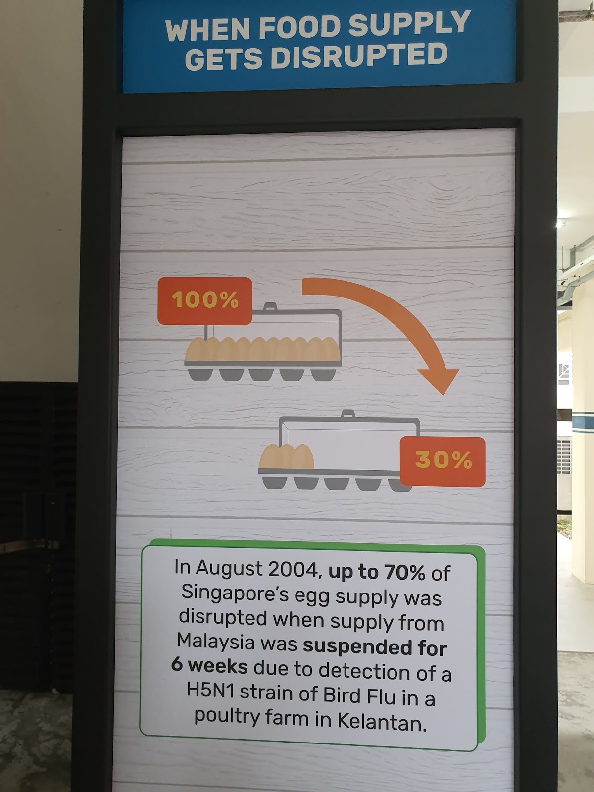
In 1999 there was a virus outbreak which disrupted supply of fresh pork
2003 SARS outbreak Pasir Panjang wholesale Centre some workers were quarantined so vegetable supply disrupted. closed for 15 days.
Bird flu in China from end of 2013 to 2014 near CNY.
Prices go up when food supply disrupted disruption of onion supply from India. government ban as insufficient supply due to delayed monsoon, flood etc onion from egypt, turkey, china etc tough for bangladesh
Malaysia prohibited export fish and eggs jan to feb in 2018.

 3 Food baskets 

1.Diversify import sources. reduce risk of reliance on any one supply source e.g. eggs from Ukarine, New Zealand majority from Malaysia andSingapore farm

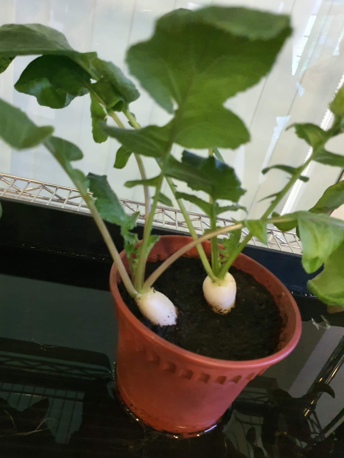
2. Grow local. helps mitigate our reliance on imports and serves as a buffer 0. grow overseas. support our companies to expand and grow overseas   e.g. Apple from South Africa    use less to produce more   ambitious target 20 to 30% not possible to be 100% self sufficient. Back to planning ~agricultural land cluster at yio chu kang coastal lim chu kang, changi. Citiponics on roof top of multi storey carpark @AMK brand leaf well commercial farm utilizing space Elderly from nearby home only work in early hour of morning. transplanting or harvesting involve the community. Certain portion donated to the home sky green vertical farms. sunlight indoor controlled environment. water, nutrients etc 
St John island R&D sea bass 20% bigger
Meat based diet requires a lot of land and cattle release a lot of methane, a greenhouse gas Science base using technology to help grow plants and fish  grow overseas  how can we support? 

3. Growing overseas. Singapore help in the setup pig farms in China Prime mahkota brand fr China, local fish farm

Q&A

 4th basket national stockpile?

Singapore works with ASEAN countries controls of export or imports e.g. FAO representation diff guidelines for diff countries e.g. some relevant only to EU.   NTUC fairprice carry the largest local grown food widest vegetable range comcrop, panasonic salad, mushroom, fish from Apollo. Pasar NTUC housebrand can be fr Malaysia etc which they would put the country of origin how is local farmer supported in terms of price? freshness, sustainability (support local), safe as random check by SFA.

Challenges in relocating the farms e.g. MINDEF taking back the land, some tradeoff when new land is released it is based on best concept rather than just price if the land is not as productive and lease is up, it will be given to a more productive purpose agricultural productivity fund. Farmer can apply the grant to invest in equipment or technology which can increase productivity 50 to 60% e.g. sensor to monitoring , cut on need for 24 hour manpower

Panasonic Farm visit

Visited the Panasonic Factory Farm organised by SFA and Geog unit after the Full Geography Seminar.

It is the 1st farm which has both the farm license and food processing licence.

We were shown a video on the indoor farm as well as how to use a veggie life cultivation kit and reminded not to put the seeds too deep into the soil, not more than 10 cm. It will take around 35 days to mature as compared to the traditional farms' which take a longer growing period of 6 weeks to 2 months. If school wants can contact by SFA online at $10 per participant. Each participant will be given the veggie life cultivation kit and a bowl of salad. I must really say the salad was so crunchy and delicious as it's fresh from the farm!
More exotic japanese plants were grown in the factory farm which is 30% cheaper than imported. Our guide explained to us why red and blue lights are used. For photosynthesis, red light control a parameter and blue another. The amount of light used is customised to the plant grown. There is also control of water and nutrient as well as enhanced co2. Same music is played (mainly classical) to encourage plant growth. Air flow/wind is used to toughen the plant.
Some are planted in peat from European countries
And some using Hydroponics. Some are hybrids. We 
We saw from the monitor the prep room, harvesting room and Processing room.

With the controlled production, there is a stable supply and there is quality assurance and no pesticides is used as no pest can enter. It has a Shorter lead time and is not at mercy of adverse weather and not affected by price fluctuations.

There is also increase productivity with the use of automation for example, 11 instead of 27 labour is needed. 

Though investment cost is higher for hydroponics, operation cost (less labour) is lower. Hydroponics technology is more matured compared to aeroponics and aquaponics. Moreover, Aquaponics has high risk.


Panasonic sees food production as part of corporate social responsibilty contributing to food security. Our guide mentioned that the biggest challenge is consumer education as it is more costly for indoor produce. 

In Singapore, 90% of the vegetgables are imported as the vegetables are cheaper due to economies of scale. For local produce, other than government support, consumer support is definitely needed as when there is more demand and more are produced, the cost can be reduced. 


https://www.panasonic.com/sg/corporate/news/article/singaporeindoorfarm.html

VR in Geography

Applauding the efforts of the team from Hua Yi Sec in using VR in teaching Geography concepts.

You can log into cospaces app and look at the 3 experiences which they have created to get the students to explore the unique features of a Place in Geography.

You can search for Clementi, Tiong Bahru and Ang Mo Kio in cospaces. It seemed that CCPD had also created the VR experience of the mangrove Sungei Buloh and will launch with the new slower sec syllabus.


VR  in inclusive housing in Singapore
Clementi 


Tiong Bahru 
https://edu.cospaces.io/AGB-QTF


Ang Mo Kio 
https://edu.cospaces.io/NGG-XCG


Definitely excited to learn about Cospaces and how you can add the animated characters to theVR experience using Blocky. Will definitely explore!


They have also created the VR experience as a virtual reccee for their Upper Sec fieldwork at Orchard Road.

They have shared other VR resources available online such as the one on Malaria in Tanzania.

and the ST simulation of rising sea level in Singapore.

What I would like to add on:
360 view of an sea arch:


Thursday, August 22, 2019

Open classroom on using SLS to teach geographical concepts

Greendale Secondary School open classroom on the topic deforestation. An opportunity for us to see how the teacher uses SLS to blend in assessment for learning and geographical concepts in the teaching of the topic on "impacts of deforestation". Tapping on the embedding function and the use of simple analytics from students' responses, the lesson showcases the use of updated features such as the thinking routine in SLS.

We were given a chance to view a blended lesson 1 of 2 lessons in the sub topic of impacts of deforestation with a class of 40 Sec 1 students.    

The teacher made use of the SLS platform to support the inquiry based learning.  The teacher led the class in looking at the geographical issue with a poll in SLS on what the students think is the most significant impact of deforestation. He proceeded to task each pair to look into an assigned impact with a variety of geographical resources in the form of text extracts, diagrams and videos embedded in SLS i.e. E1 pair to look at impact on biodiversity, E2 pair to look at impact on water catchment and E3 on enhanced greenhouse impact. The students recorded what they had learned from the resources on the impact assigned to them in the SLS thinking routine. The teacher quickly bookmarked a few responses and highlighted some concepts which the students had shown to be lacking in their understanding from the thinking routine responses. e.g. the teachers clarified what is surface run-off and how it can contribute to river flooding. He also made a point to highlight the inter-connectivity of the various impacts. 

Then the students proceed to change their partners at their table to share with the other students on why the impact is more significant than the other (expert group strategy). The lesson ended with a revisit to the question on what they now think is the most significant impact of deforestation and the students responded individually on SLS thinking routine.

The design map of the lesson shared:


Before we proceeded to the classroom to observe the students for the lesson, we were reminded that we would be taking turn to be at the tables to make the observation of students' responses. (20 seated at the tables with the students and 20 seated at the back to observe and then swopped).

We were given the following recording sheets to record our observations:


The sharing ended with a discussion on the planning and enactment considerations in the conduct of the lesson. What we observed in the lesson which thinking was made visible and how students collaborated to make sense of the geographical concepts as well as how formative assessment was weaved into the lessons.


 Our takeaway:


Thoughts on the lesson shared with us-

1. Be willing to give up some control - a true student-centered lesson needs to be led by student actions.

2. Using SLS means students can access learning materials in their own time, at their own pace - they are not limited by their prior knowledge or access to information.

3. Have high(er) expectations of students - they will usually surprise you with what they are capable of.

4. Consider the highest value use of classroom time (e.g. discussion, sense-making) & do that.

5. An SLS lesson can be covered over several F2F sessions - you can release segments over.

6. The definition of what a lesson is can extend beyond classroom time (e.g. pre, post lesson learning) - we may want to explore how we think about lessons and reframe our definition of what constitutes a lesson.

7. The 4 Vs of data - value, volume, velocity, veracity - make managing student inputs increasingly challenging. We will need to evolve new strategies for managing them.

8. One strategy to manage the increased volume & velocity of data might be to consider peer/self-assessment strategies, both online (e.g. have students comment on each others' responses) & F2F (e.g. getting students to clarify with each other).

9. We should use SLS to make our teaching better, not only easier - it should make low-value activities easier (e.g. searching for resources, collating student inputs, distributing feedback) & free time up for us to do more high-value activities (e.g. designing learning experiences, exploring different ways to reach out to different students, crafting feedback). 

10. The learning artefacts (e.g. student responses) of one lesson can be used as teaching materials in subsequent lessons.


SLS is an enabler for better teaching & learning:

1. Rich repository of quality, curriculum aligned resources

2. Promoting visible interaction (student-content, student-student, student-teacher) for learning

3. Opportunity to change the way we deliver learning experiences (e.g. more inquiry, authentic conversations)

You can refer to some of my posts on the use of SLS @

http://ezitnew.blogspot.com/search/label/SLS?m=1

Monday, May 20, 2019

Photo interpretation using Jigsaw planet

Learned this from Lesson posted on edumall by Gerald Tay. http://subjects.edumall.sg/cos/o.x?c=/subjects/pagetree&func=view&rid=6755 (you must login to edumall to see this) He actually made use of the jigsaw planet to create jigsaw puzzles online to stimulate the student's interest in the learning of the topic "Geography of food".

The jigsaw puzzle is quite an interesting tool - I will actually use this in photo interpretation for the topic on coastal studies - http://www.jigsawplanet.com/?rc=showpuzzle&pid=330ea41ef34d&ret=%2F The teacher create the puzzles online and the students will have to highlight the main features on the photographs and relate them to what is being taught - eg. landform, process, coastal protection etc.


Play the "FB IMG 1554079059390" puzzle! https://www.jigsawplanet.com/?rc=play&pid=38ebac73ffc7


What are the coastal features shown in the photograph? How are they formed? 
Which type of waves are associated with the formation of the features shown in the photograph?

Quite a number of teachers are also using it as clues for digital escape room!

Saturday, May 18, 2019

Compass direction and Compass bearing simulation using Geogebra

Awesome sharing by Wei Sern from SGLDC on creating interactive exercises in Geogebra. This is useful especially when embedding html code is available end of June in SLS. You can also use the code to embed on Google sites and Blog (like the one below)

Reading compass bearing created by Wei Sern:

https://ggbm.at/hydx8tm2


1. Check the box next to "Use Protractor" so that the protractor will appear.
2. Read the question on where to measure the bearing from.
3. Select "Move compass to A or B" as shown in question.  E.g. point B
4. Drag the protractor and rotate it so that O points to the north. (If the angle is more than 180° then rotate the protractor with 0 starting from South and the read the angle. Add 180°to the reading.)
5. Drag the pin head so that the line intercept with the point it is measuring to e.g.point A
6. Read the angle from the protractor and enter the number into the keypad with the degree symbol.
7. Click on "Enter Check".


If you want to get the code to embed, you need to download the GGB file  (e.g from https://ggbm.at/hydx8tm2)and then upload as your activity in your GeoGebra account. Then in your GeoGebra account you can follow the following steps to get the code to embed in you blog or site:

I have commented earlier how I missed the earlier ETD game of using interactive game to learn compass bearing. Learned from him that compass bearing is also learned in O level E Maths and that he could create the simulation in geogabra.  Students kinestatically learn how angle bearings of one location from another is referenced. It allows the sttudents to move a virtual compass and then input the value of the angle.

The original exercise had some drawbacks when used on a mobile phone, hence he had improved on it by including a virtual customized keyboard which allows the activity to be run on phone browser with better graphics control and interface.

He also mentioned that the protractor tool can be made into a template file and inserted into any existing good quality Geogebra geometry activity resource without too much effort! It can be downloaded from
 https://www.geogebra.org/m/t6v92Gdz#material/tedq8qnf 

Can you move the animal to the correction direction?


https://iwant2study.org/lookangejss/math/ejss_model_Eight_point_compass3/Eight_point_compass3_Simulation.xhtml

Saturday, April 27, 2019

Interactive media for map reading on SLS

So happy to find that interactive media from ETD is now included in SLS. Would really hope that the older interactive e.g. grid reference - fun with building and grid bearing - flying a plane are also included! The only draw back with the existing one is the absence of 4-figure and 6-figure grid reference. However still love the games Sailing with bearing and Quest of Arudra Island.


Added the interactive media on lesson review - "How to read a map (part 2) features of a map."


Added the interactive media on the game  "Quest on Arudra Island"


Added the interactive media on the game  "Sailing with Bearing"

To overcome the issue of the lesson review not showing the 4-figure and 6-figure grid reference, thinking of using the thinking routine to get the students to draw it out.